


Pointe de Kermovan/Fort de l'Ilette. 22/08/19.

Dervalmarc
User
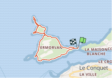

Length
3.9 km

Max alt
23 m

Uphill gradient
44 m
Km-Effort
4.4 km

Min alt
0 m

Downhill gradient
44 m
Boucle
Yes
Creation date :
2019-08-22 16:10:03.314
Updated on :
2019-08-22 18:11:28.143
1h53
Difficulty : Easy

FREE GPS app for hiking
 SityTrail
IGN / Geographical institutes
SityTrail Plus
The world is yours!
About
Trail Walking of 3.9 km to be discovered at Brittany, Finistère, Le Conquet. This trail is proposed by Dervalmarc.
Description
Courte ballade. Points de vue sur les îles de Ouessant et Moléne.
Photos


Positioning
Country:
France
Region :
Brittany
Department/Province :
Finistère
Municipality :
Le Conquet
Location:
Unknown
Start:(Dec)
Start:(UTM)
368518 ; 5358314 (30U) N.
Comments